Camprodon
Camprodon | |
|---|---|
 | |
| Coordinates: 42°18′57″N 2°22′00″E / 42.31583°N 2.36667°E | |
| Country | |
| Community | |
| Province | Girona |
| Comarca | Ripollès |
| Government | |
| • Mayor | Francesc Xavier Sala Pujol (2015)[1] |
| Area | |
| • Total | 103.4 km2 (39.9 sq mi) |
| Elevation | 988 m (3,241 ft) |
| Population (2018)[3] | |
| • Total | 2,261 |
| • Density | 22/km2 (57/sq mi) |
| Demonyms | Camprodonins, camprodonines |
| Website | www |
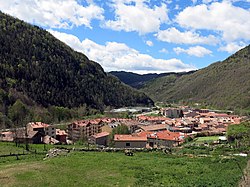
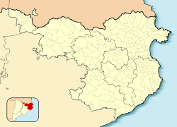
Camprodon (Catalan pronunciation: [kəmpɾuˈðon]; from Camp Rodó "Round Field", ultimately from Latin Campus Rotundus) is a small town in the comarca of Ripollès in Girona, Catalonia, Spain, located in the Pyrenees, near the French border.
History
[edit]The settlement of Camprodon was in 1118, when Ramon Berenguer III allowed the building of a market near the monastery of Sant Pere de Camprodon, which is located in the present-day town. In 1252, Camprodon was granted the title of royal city and left the jurisdiction of the abbot of Sant Pere.


The city celebrates the feast day of Sant Patllari (Palladius of Embrun), and the church of Santa Maria de Camprodon claims his relics, which lie in a 14th-century reliquary (arqueta de Sant Patllari).
The epicentre of the Catalan earthquake of 1428 that killed hundreds of people was near Camprodon.[4] The earthquake was related to the active Amer-Brugent fault system which lies to the south-east of Camprodon.[5]
Notable people
[edit]- It is the birthplace of the musician Isaac Albéniz, and has a museum dedicated to him.
- Ski mountaineer Marc Solà Pastoret was born there.[6]
References
[edit]- ^ "Ajuntament de Camprodon". Generalitat of Catalonia. Retrieved 13 November 2015.
- ^ "El municipi en xifres: Camprodon". Statistical Institute of Catalonia. Retrieved 23 November 2015.
- ^ Municipal Register of Spain 2018. National Statistics Institute.
- ^ Banda E and AM Correig (1984). The Catalan earthquake of 2 February 1428. Engineering Geology, 20:89-97.
- ^ Olivera C, Redondo E, Riera A, Lambert J and Roca A (1999). "Problems in assessing focal parameters to earthquake sequences from historical investigation: the 1427 earthquakes in Catalonia". Proceedings I Asamblea Hispano-Portuguesa de Geodesia y Geofísica (CD-ROM). Symposium Ibero Maghrebian historical and instrumental seismicity. Vol. SIM2-7. pp. 1–8.
{{cite conference}}: CS1 maint: multiple names: authors list (link) - ^ "Skimountaneering.com". Archived from the original on 21 July 2011. Retrieved 22 August 2009.
External links
[edit]- Official website
- Government data pages (in Catalan)


